Wednesday, July 30, 2008

Head in clouds: 27th July 2008: Mahuli

Trek path: reach asangaon/shahapur, travel to mahuli village, trek upto mahuli fort, roam around the various regions of the fort, trek down and return along the same path.

Time required:
to reach asangaon/shahapur - from mumbai to asangaon by local train is about 1:30 - 2:00 hrs, by road from mumbai to shahapur is abt the same,
to reach mahuli village from asangaon/shahapur - 1 hour by walking, about 20 - 30 minutes by auto rickshaw.
to trek from mahuli village to mahuli fort - between 2 and 2:30 hrs.

Height: 835 metres (2785 feet), highest point in thane district.

Trekking experience required: this can be a beginner level trek, since its quite easy with no patches and also takes a short time.

Fitness required: moderate level of fitness without injury or sickness.

Fear factor: most of the trek is along mountain paths with safe gradients, however there r some areas along the path where one has to walk along narrow ledges overlooking steep cliffs and sheer drops on either one or both the sides of the ledge. extra caution is to be taken while negotiating those.

trek story:
part 2 of our trekking expeditions brought us to the strategically important fort of mahuli, which was under the control of the great shivaji's father shahaji raje. the marathas cud control the trade route between kalyan, the port city of those times and interior maratha powerhouses like pune. it was also a defensive bastion for interior maharashtra from invaders from the coast. the reason for choosing this trip was its extreme proximity from our homes. 30 minutes of commute, thats it. it was a sunday trip so we had to make sure that we wud come back the same day and attend work the next day.

first we commuted to asangaon by train:
the best part of this trek was the extremely short distance that we had to travel to get to asangaon. the three of us decided to board the same train and the same coach. yogesh from dombivli, nikhil from kalyan and i from shahad. we managed to do that, all of us on train by 5:40 am. the commute was along a really picturesque route, presenting mountains covered in greenery hiding the valley of the kalu river amidst them. asangaon is 30 km away and a half an hour commute from shahad. stations r far and few in between, so the train just blasted through the rails at top speed and reached asangaon on time and alighted there at around 6:10 am. then we had some crisp toast and tea at a small shop that managed to open so early.

next we went to mahuli village:
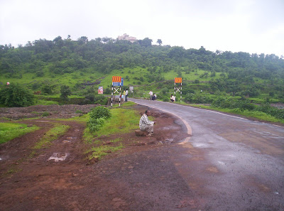
just above the tracks that continue from asangaon on their way to the north of the country, the National Highway 3 stretches across on a wide flyover, from which a small road branches off towards the hilly regions. we walked along the tracks, scaled upto the highway along a narrow embankment which kept the road above the tracks. then we crossed onto the other side of the highway and were on our way to mahuli by taking the branching road. although this road ends abruptly in the mahuli village, the boards along this road dont seem to boast about this beautiful trek, instead they talk about a temple by the name of "manas mandiram". we got to know that it was a jain temple. it started 10 years ago, but its popularity only rose during the last 3 years.
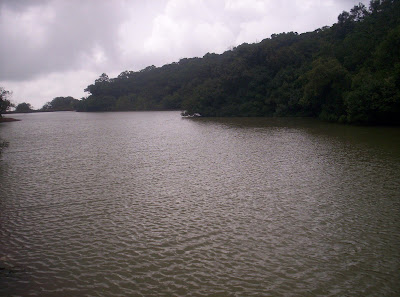
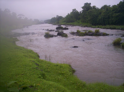
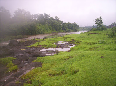
along the way, we peeled off into a path that led us to the foamy water of what we think is the kalu river.


after washing our faces we continued along the original road towards mahuli.
we had to stop at a checkpoint where trekkers to mahuli have to pay Rs. 20 per head and obtain a gate pass to continue on, something like toll payment, but also for people who come walking here like us, not just vehicles. we paid up the amount, collected the receipt and moved on. along the way, we saw a dam which controlled water inlet to the tansa lake, one of the lakes which makes this area politically very powerful, bcoz this lake is one of the 7 lakes that supply water almost all over north west maharashtra, including mumbai city itself.
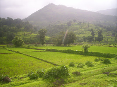
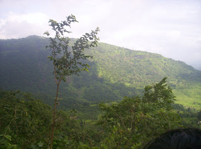
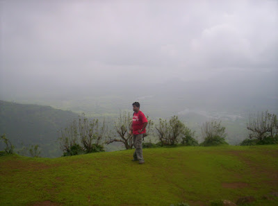
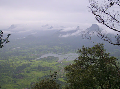
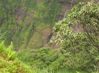
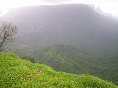
the general picture was that of greenery. lush green fields, mountains covered with green trees, capturing grey rainy clouds on their tops. it was almost like what they show in movies and tourist postcards or discovery channel. but throughout we had a problem where our camera just couldnt snap past the mist and we ended up having really cloudy photos. we have decided to return to this trek sometime around november so that we cud return to spots where rain and slippery paths kept us out.
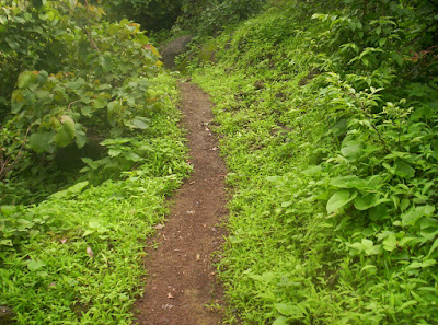
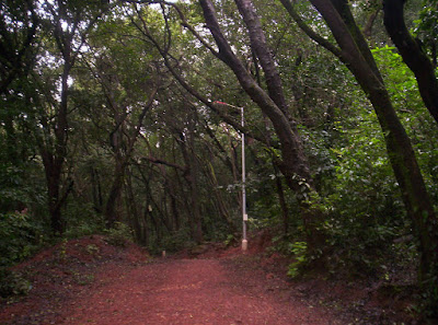
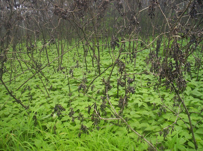
the beautiful mahuli village gave way to the trekking path. this trekking path is frequented by trekkers and some of them have marked the path nicely in a sequence of white arrows over selected rocks, so its difficult to get lost on this trek. we noticed a lot of crabs along the path, crabs in an assortment of colours which i dont think i will ever get the RGB combinations of. and there were a lot of snails as well. this was peak of monsoon and it was evident from the flora and fauna around.


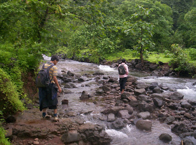
to announce the peak of monsoon, the next thing we had to negotiate along our path was a roaring rivulet with a really powerful current, swelling with the overnight rain. i swear we cud have gone white water rafting in this one. we spotted rocks along the way, which cud carry us to the other side without us having to step into the massive currents.


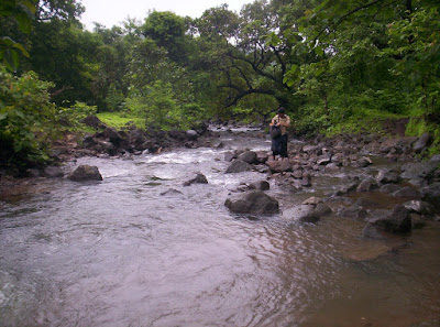
somehow we reached the other side, where tell tale signs of ascent began. along the path we cud see a stone staircase leading to the fort at the top. the structure of the stairs told us that they were part of the original design of the fort. of course the majority of the stairs r now covered under rocks and mud after all these centuries.

we trekked blissfully to the fort:

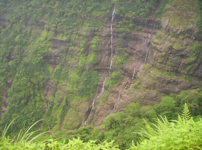
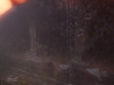
the trek was completely blissful with the usual mountain winding paths. one thing that was happening quite a lot that day was the rain clouds blocking and clearing the path like playing hide and seek. this happens quite a lot on sahyadris during the rainy season bcoz the sahyadris trap and clouds with its thick tree cover. along the way we heard birds singing, monkeys hooting and brooks and waterfalls splashing. then we came across a section of path where the administrators had wedged a steel ladder into the mountain. had it not been for that ladder, this area would have needed patch climbing, thus wooing away more than 50% of the trekkers who r not comfortable with the idea of patch climbing. still, i and yogesh, adventurous that we r decided to avoid the ladder and climb the patch anyway. after a lot of slipping and slider we decided to set aside our risky appetite and sheepishly went up the ladder after having wasted 10 minutes !!! another two climbs later, we came across a rectangular hole carved into the ground with staircase leading to it. this was a water cistern, used to collect rain water. the collected rain water used to serve the maratha guards during other seasons. we really cudnt see the bottom of the pit, so i think it wud have been pretty deep, at least the height of two average heighted persons. after another 5 minutes of trekking we saw fort walls and guard posts and another ten minutes later we reached the interior of the fort campus which had the famous caves.


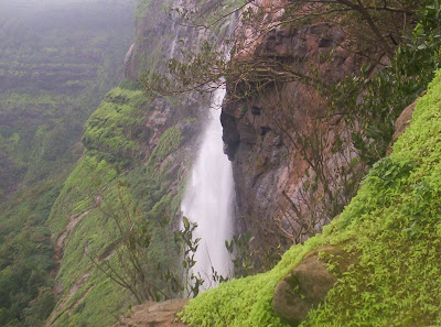
in fact a lot of trekkers come here seeking the caves and the surrounding waterfalls. but we were here to see the entire fort. a lot of trekking groups were around the caves behaving disgustingly and throwing rubbish around the place as if the caves were dustbins. both male and female trekkers were present there and behaving like drunk. we staying in the cave for hardly 15 minutes and decided to move on to see other things. by now the rain had started to pour incessantly.

cloud cover and a little scare spoils our further trekking hopes:
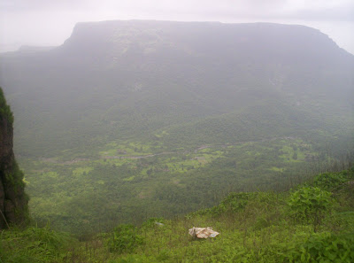
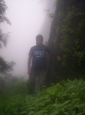
when we tried to see around us, to see what other things this fort had to offer besides the stone walls, the cave and the entrance, all we saw was dense cloud cover. in fact a lot of times we cudnt even see how high we were from the ground level. we wud have been about 2700 feet according to mahuli references that we found on internet, but we cudnt see the sheer drops and the depth of the ground level until the clouds cleared out some five minutes later, only to come back again.


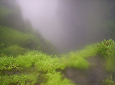
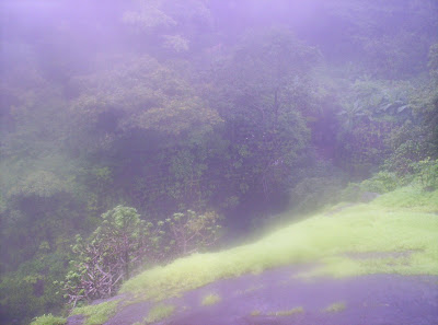
we tried to trek to other places around this fort, but had to give up after cloud and mist didnt budge for a while. also the conditions were atrocious for any sort of photography.
we did try to explore further when we uncovered a path, that we later came to know led to a portal called "Kalyan Darwaja". however the path was almost completely covered in vegetation and we had to break cobwebs of some poor unsuspecting spiders. here, yogesh taught us how to part vegetation aside with a long stick in order to look out for creatures. we continued deeper into the forested area where the vegetation kept getting thicker and thicker. it was clear that locals visit here occasionally to gather bamboo shoots, since we saw quite a lot of shoots. but on this day, this area was deserted, or so we thought, since we kept hearing strange sounds. even now we r not sure what it was, hunting creature, assassin, ghost :). but it was enough to petrify us and we returned back to the main fort. trekking around here in dense vegetation and cloud cover in this area is definitely dangerous and unpredictable. so we decided that more exploring cud wait until an encore in winter.

Descent:
the descent was not completely blissful. the skies opened up and it rained very heavily. we were shivering in the cold and wet conditions. nikhil was the worst sufferer. his hands seemed to go into a deep freeze. the numbness didnt allow him to grip properly. we were also skidding every now and then and getting twisted ankles and knees or hurt toes.

Back home:
but nothing serious happened anywhere and we reached mahuli village again. here just near the gate pass station, we had wonderful hot vada pav and tea. everything tastes gr8 after a tiring trek. then we continued to asangaon and there had some chicken soup to warm ourselves up along with fried rice. we finished in time to catch the 5:36 mumbai local train to reach home.

Monday, July 21, 2008

The quest begins: July 19 2008: Dhodhni - Matheran - Neral

trek summary:
Trek path: reach panvel, catch a bus to maldunga and alight at dhodhni bus stop, walk to dhodhni village proper, trek for a couple of hours to matheran, enjoy matheran like a tourist, then walk along the matheran - neral road, reach neral station, catch a mumbai bound local train if u r bound for mumbai, or karjat train if u r bound for pune.

Time required: panvel to dhodhni by bus - 30 minutes, dhodhni to matheran - 90 to 120 minutes.

Height: 850 metres (seen from board on matheran station)(ie. 2833 feet)

Trekking experience required: None really, this can be a starting point for budding trekkers, highly recommended for trekking enthusiasts who never had a chance to actually do it.

Fitness required: a moderate level of fitness, something like if u can easily climb 6 - 7 storeys without a lift everyday, then u can attempt this. its better not to have a heart or respiratory problem since some parts of the trekking path are pretty demanding. also, dont go carrying an injury to any of ur limbs, u will aggravate it for certain.

Fear factor: one good thing about this route is that, it doesnt have too much of a problem for people fearing high altitude. u hardly get a spot where u have to see deep down into a ravine. the slopes in this route are simple rolling gradients with no sheer vertical cliffs. all in all a perfect beginner's level trek.

Things to carry: only a lot of water is really required. u can eat at matheran since the trek takes only 2 hours at most.

trek story:
this was the first trekking we took in our series. the trekking was from a village named dhodhni which is about 10km from panvel, navi mumbai, upto the famous hill station of matheran. the travel upto dhodhni was by bus and thereafter, the trek was upto matheran, which is at 850m above sea level.

first step was to get to panvel:
i stay at shahad, which is near kalyan, a very important railway junction, so i asked yogesh to come up there since i cud park my bike at the very expansive kalyan railway station parking complex. from there we cud move onto the nearby kalyan bus terminal to catch the 6:15 am bus for panvel.
for anyone wanting to do this trek, it is important to get to panvel first. u can reach panvel by local train from Mumbai CST or Kurla . or u can also take a bus from dadar or sion. there r also state transport buses to panvel from important cities like pune, ahmednagar and from all over maharashtra.

then after some refreshment, moving onto dhodhni:
the bus from kalyan reached panvel at 7:30, and the bus that was to connect dhodhni was to leave panvel at 7:50. so we had some refreshment and stocked up our back packs with some snacks for the trek.
by the way, u can catch any bus that goes to a place called maldunga. any maldunga bound bus plies through dhodhni. the first bus to leave for maldunga from panvel is around 6:30 and it reaches dhodhni at around 7:00. but personally for me to catch this 6:30 bus from panvel, i dont have any public transport to take me to panvel itself at that time, so i would have to rely on my bike all the way to dhodhni instead of parking it at kalyan :) anyway that sentence has set my spine tingling, since an early morning ride to dhodhni will be a mouth-watering prospect. this time i didnt know the road route, so next time, its gonna b dhodhni by bike.
anyway the dhodhni bus ride presented some breaktaking scenery of large village fields, bordered by tall green covered mountains rising into the ready to rain clouds. there was a light shower all the way through the ride. just before we reached dhodhni, we saw the reservoir water collected by the Gadeshwar dam, that is just on the outskirts of dhodhni. in fact u wud never know that u arrived at dhodhni unless u pass by the dam and the formed lake.

we arrived at dhodhni:
we got down at the dhodhni bus stop, but soon found out from the locals that to reach the base of the mountain that rises to matheran, we wud have to walk a couple of kilometers. sure enough, to cement that fact, the dhodhni bus stop did have a milestone announcing the distance to dhodhni village proper.


but once again the walk was so pleasant that we never minded the distance. the entire mood of the area was green. once again plain flat fields merged with slopes, which increased in gradient to rise away into green mountains, each wrapped in silver ribbons of waterfalls all across. i say ribbons bcoz thats exactly what they looked like and even behaved. the direction of the waterfalls swayed with the wind. the waterflow from the falls were not thick, but fine misty sprays, deflected and redirected every now and then, as if the mountain had a mouth and were blowing on them !!!!!


oh yeah, i must also bust an age-old myth here. i was wearing a bright red t-shirt that day and there were herders herding their bulls, some guiding them to the vast grass pastures to graze, some about to tap their enormous strength to plough their fields. in any case, a lot of bulls crossed our path and they didnt have the slightest interest to attack me as is shown in movies, where bulls charge down anything red. in fact i noticed that they didnt even look at me. and here i was, expected to be gored to a thousand unrecognizable pieces.
when we reached the village, some locals guided us to the base of the mountain that we were to trek on. i must it was the most unexpected mountain base u wud see. the mountain base did not face some open grassland or something like that. in fact we had to pass along a temple and then onwards into narrow concrete paths between clusters of houses, as if we were walking into a colony of slums at the foot of the mountain. but soon we realized that we were headed to the right place, for when we came out of the cluster of houses, we saw a fairly steep mud path hewn into the grassy mountain and continuing in a zig-zag pattern into some unseen distance. yippee, we were ready to begin.

climb upto our first landmark, the base of a lengthy waterfall:
the path rose for sometime, then it suddenly opened onto a flat grassy area in the middle of the mountain. we took our chance to rest for sometime under a tree and eat something before we moved on. once we were ready, we continued to move across the clear but steadily rocky and rising path. to our fortune, the path never forked into confusing array of pathways or deadended anywhere. it was clear that this was a trek tailormade for a complete newbie. in fact, if someone were to crib about this trip, he / she is not ready for any sort of trekking. the other thing about this path is that it abounds in flora and fauna. we keep hearing birds which sang as if a human was whistling, then monkeys playing around, snakes resting in the sun and a lot of wild fruits and berries lying ripe along the path, but we never tried to eat those fruits since we didnt really know which ones were edible.


we moved on until we heard a progressively increasing gurgle of water.
the path suddenly opened into a rocky area which was being washed continuously by a not so thick, yet a very long waterfall. we were now mid-hill and the waterfall seemed to come from somewhere out of our line of sight and drop into a depth again out of our line of sight. the water was fresh and cool and we drank and washed our face to move on.


very few things ever went wrong on this trek, but one of them happened now. i was climbing up some rocks to get good photos of the waterfall and when i came back to the path to resume on our journey, i jumped of a large rock and my back pack's left strap snapped. oh bother, ok, i didnt mind, fastened my waist strap and carried on with the right strap on, leaving the left strap dangling. it was to be a big mistake. still oblivious to what wud happen some minutes later, i marched forth.

i stuttered and struggled to the summit:
after sometime, the one-sided weight tugging on my right shoulder became unbearable. the rain had stopped but the humidity was high. i was drenched in sweat. i took off my tshirt and was trekking with only my vest on. my only respite was that my shoes were giving me infallible grip. yogesh too had problems of his own. his shoes were slipping and sliding on the moisture and moss. he too was dehydrating in the heat, but not to the extent i was.
then after some time the grade increased and we had to face a deep cliff to our right a lot of times, treading carefully in narrow ledges and sometimes on moss-covered rocks, but neither of us faced any huge problems that wud make us return downstairs and abort our trek. everytime we, especially i, faced exhaustion and high pulse rate, we wud stop for sometime, just admiring the beautiful vista of the mountainside and recovering pretty fast due to the squeaky clean oxygen at this altitude.
we trekked on for an hour and a half, then as suddenly as the trek started it was over. we absolutely suddenly reached the summit and were facing the open pasture of sunset point on the northern end of matheran. we had made it. 850 metres or 2833 feet of vertical distance covered, absolutely no idea how much actual distance it was along the path. all in all a really uneventful trip. we had everything positive, good fogless weather, no slippery rain, no noisy trekking parties along the way, no drifting of path, no injuries, nothing. a really uneventful trek from 9:20 am to 11 am. thats it.
the wonderful vista looking down below to the point from where we started our ascent combined with a sense of achievement was a really special feeling indeed. we were standing at sunset point on the outskirts of downtown matheran.


On our way to the main town:
we continued on our way towards the main town along the muddy path that was everywhere in this area. instead of paved roads, matheran has parts of ground clearing of grass and shrubs and that is what they call roads to each of their points.

on the way we came across a mountain face which was a sheer drop and down the middle of this drop was a thin wind-swept waterfall. i snapped it all the way upto the bottom, but unfortunately the bottom of the waterfall was not visible to us at all. it was hidden away by plants and trees growing sideways from the wall of the cliff on which we were standing !!!


as we were walking, we saw a really interesting wall which was completely engulfed in shrubs. we saw several more of those later on throughout the day as well.


we came across a point where the path forks into 5 more places and headed towards the one which made way to the main town market bazaar peth. as soon as we approached the area we saw a sizable weekend crowd holidaying there. obviously they got there before we did by more traditional ways. once inside the town, we noticed that the roads here were not muddy clearings, but cobblestone pathways.
the first thing u notice here r the two common means of transport. as we entered matheran, we saw the narrow guage matheran station. trains come here 5 times a day from neral station which is on the way from kalyan to karjat. the second thing is that motor vehicles r not allowed in matheran to keep the air clean. they have to be left in the pay-and-park area at dasturi naka, which is about 4km from the town. so if u r not too keen on walking around or if u r too tired, u can use horses, although be ready to haggle a lot for getting reasonable prices. personally i have not done horse-back riding in matheran.


we were pretty hungry when we got here, so we wanted to finish lunch. but i must tell u, we had proper lunch only at 4pm that day. now at this point, it was 12:15 in the afternoon. we found a cart selling corn-on-the-cob, which tasted very different from what i regularly have. this one tasted very fruity instead of the usual crisp. we finished a cob, being continuously pestered by a stray goat, which refused to move until we obliged and fed it some groundnuts, which also we were having along with the cob. after that we had a cold drink. now we were too full to have lunch, so we enquired about routes which descended down to take us to some railway town, so that we cud go home by train. almost everyone we asked pointed us to the end which was completely opposite to where we arrived. almost everyone mentioned the one tree hill point which was orthogonally on the opposite end to our summit stop, the sunset point. so we decided it was good to explore descending trekking possibilities at one tree hill point. we decided to go there and come back to town to have lunch. the caveat was that this point was 2km away. we started walking and along the way met a woman who was taking some cargo down to the base of the mountain. we chatted her up to ask for direction of the descent. after what seemed like eternity we finally reached the one tree hill point and saw the woman go down the track that everyone seemed to point out.

One tree hill point:
along with the track that the woman went descending, we saw another mountain which had a flag affixed to its summit. it was connected to our mountain by a tiny strip of land and still required a lot of patch climbing to reach its top. judging from the amount of moisture on both the descending track and the flagged mountain, we decided it was the day for newbie trekkers like us to do it. we decided to return to this spot in summer. now it was time to head back to town for lunch. but we did manage to get some breathtaking pictures of the scenery around one tree hill. a huge lake created by the reservoir of morba dam lay expansively below and there were mountains with sheer cliffs everywhere. one tree hill point trekking path was surely not for the faint-hearted !!! and the woman whom we saw while reaching here was definitely not faint-hearted either. she went midway through the precipice and realized she had forgotten something on the top. so she actually clambered back up and hauled back whatever she was looking for and sauntered back downstairs with a basket on her head and slippers below her feet. and she claimed to do this sort of daredevilry every weekend !!!


owing to a mistake we saw the charlotte lake:
while we were trudging back hoping to reach the market place again, we lost our way and were walking towards charlotte lake. since we had erred already and come so far, we decided to let lunch wait and proceeded to the charlotte lake. this error led to a pleasantly surprising rendevouz.

we reached charlotte lake and roamed around the area like any other tourist. but we found a small secluded area with a pumphouse where no one was venturing, so we decided to see if we cud see anything interesting there. sure enough it was interesting, really interesting. it ended in a cliff riddled with waterfalls. we were standing on the top of a waterfall released here by the dam that bordered the charlotte lake. a lot of rain meant that the dam vents were opened and a lot of waterfalls were allowed to escape into the deep void a kilometer beneath us. there was a really enormous waterfall and a little one which no one seemed to visit. the little waterfall was interesting bcoz its moisture was swirling around in the wind. to see how water droplets behave in the really gusty wind, we threw some of our leftover drinking water into the void, and sure enough, some of it actually came swirling back upwards to hit our faces. it was really magical. then we inched away as a couple came to this area looking for solace, their disappointment obvious on seeing the two of us in this area when they were actually looking for isolation from the massive crowd on the neighbouring big waterfall. thats where we went next to stand on the top of the massive waterfall with its deafening roar. the striking feature was the wind and the heavy swirling moisture everywhere. but it was too marshy here and our shoes turned a really filthy earthy brown and they started slipping and sliding under us.

when our eyes had their fill of the magnificent vista, we trekked on another kilometer to the echo point. but it was too crowded there. however we cud see the tallest point in matheran from here, the barricades around the louisa point. we wanted badly to go there. heart said go there, but practicality kicked into our minds and we let it be this time, finally heading to market place for lunch and the descent down. the sun was beginning to set behind us, so we decided that we had enough of matheran this time around :( we started back towards market place photographing anything interesting we found along the way.


the walk back to neral:
after we had our late, late lunch (4:45 pm), we walked along the railway tracks intending to go all the way with the tracks, but some localites told us to use the road instead, since the tracks rounded all the hills in the area and the roads simply cut through them. so we used the wisdom to walk along the road and found it too taxing on the ankles to walk on a hard paved road which always sloping downward at an incredible gradient. boards along the side of the roads kept reminding vehicles that these were strictly first gear slopes. we trudged all the way to jummapatti where the road kindly decreases some of its gradient. we had to stop here and have some lemonade while we tried to spill the facts about some shortcuts to neral. but the localites either didnt know or they were refusing to divulge details in order to protect their slopes from trekker rubbish. so it was the long walk along the roads that was meant for 100cc - 2000cc petrol and diesel powered machines. our feet were killing us. but finally after a lot of trial and tribulation, we made it to neral station which was reeling in darkness. we reached there at 7:40 and had to wait for 7:57 mumbai local. and believe it or not, there was a massive crowd waiting, people who were returning from their holidaying in all hill stations around neral. but they had done their holidaying by traditional means like going by bus or car, not trekking like us. yogesh actually considered missing this train, lest we didnt get a place to sit, but i insisted that we caught this train no matter what, since train frequency here was sometimes horrible, sometimes to the extent of one train every 40 minutes to one hour. i reminded him that this was not urban kalyan or dombivli, where trains from all over the place converged to leave us with more options. wisely we chose to board and thankfully got places to sit. the heat of the urban concrete was obvious especially after the coolness of the high mountains. so we struggled to sleep on board the train. moreover it was just a 45 minute commute to kalyan and 1 hour to dombivli. i got off at kalyan and parted ways with yogesh, knowing very well how much i had enjoyed the day. most of our conversation on the train had been planning the next trek.

Back home with sweet memories:
i was thankful to have come to kalyan from shahad by bike. bike ride to shahad is just a formality compared to covering the distance by train or public transit. my ankles were still hurting from the road descent. so the bike ride felt like heaven. i reached home with a series of pains developing, ankle, calf, hips, shoulders and god knows where all. but all the pain was worth it, since the trek had been a great experience. i came home much more hardened that when i had left, and got to know my body really well. i felt good to be able to do a trek so easily and realized that my body was fighting fit with very, very few problems.

thats all, folks. until my next trek, goodbye.

Welcome to the new Sahyadri Trotter

hello and welcome to everyone reading this blog. this blog is just starting out as a hobby, nothing much really, just to record my trekking achievements in and around the sahyadri range of mountains. for the uninitiated, the sahyadri (pronounced as 'sah - yaa - dri') is the name given to a part of a much longer continuous range of mountains which lines the west coast of india. this long range of mountains is called the western ghats. the word 'ghat' in many indian languages like hindi and marathi means a mountain range or mountain pass. now, back to the sahyadris, this is the portion of western ghats that spans across maharashtra from the north to the south about 75km inland from the west coast. the west coast itself covers a lot of important and affluent maharashtrian cities such as mumbai, ratnagiri, alibag, kolhapur, etc. then about 75km inside the coast, we can see the majestic stance of the sahyadris throughout the west side of maharashtra. and on the other side of the sahyadris, opposing the one to the coast, begins the deccan plateau, inside which, other important cities like pune, aurangabad, solapur, etc lie. the sahyadris form a massive fortress to the region lying to the west of india, almost like the first bastion of defence against attackers. unlike the himalayas, which were formed due to sedimentary rocks colliding into each other and rising as a result of continental drift, the sahyadris (in fact the whole of western ghats) were formed by basalt rocks as a result of solidification of magma from volcanic eruptions, which are now long defunct. the sahyadris abound in both flora and fauna especially in the monsoon season between june and september. that is when they r the tourists' and trekkers' favourite. while the majority of sahyadris wear a forlorn, dull, almost desert-like brown between november and may, they r drenched in luxurious emerald-like green in the monsoon months which entices the folks to pay them a visit and rejuvenate themselves from the fast and hectic urban lives of the maharashtrian cities, especially mumbai and pune. another important factor for these two cities to really head out to the sahyadris is the proximity and the resultant immediate affordability. a weekend sahyadri getaway for one person can be as low as 50 rupees, if all he / she wants to do is roam and trek around and not stay overnight at any hotels, lodges, etc. whereas a typical delhi / kolkata resident has to shell out 3 - 4 figure amounts and travel a mininum of 500 km or more to reach the northern / north-eastern himalayas respectively and a chennai / bangalore / hyderabad resident has to do likewise for ooty / coorg / munnar / kodai, etc, a mountain getaway with return trip for a mumbai / pune resident starts from as low as 40 rupees (local train / bus ticket fares to trekking base camp places like panvel / khopoli / neral, etc). also the sahyadris r easily accessible since the villages / towns at their foothills r superbly connected by railways and roadways and the public transport is dirt cheap. hill stations like matheran and mahabaleshwar and hill shrines like bhimashankar and trimbakeshwar r especially attractive to the new generation with fat sums of salaries and draw tourists in droves every year.

now i have personally travelled to a lot of these places myself by all forms of transport and seen and enjoyed them. yet i felt that it was not enough. every mountain i see is magical and sort of invites me to climb it. i thought that rather than just see and admire these huge structures, maybe i should interact with them, get closer to them. but its too dangerous to do it all alone. fortunately for me, i have two like minded friends, one of them being a fairly seasoned mountain trekker. with our liaison, we started on our long quest of conquering the important and prominent parts of sahyadris. one thing was that it was only possible for me now rather than later. i have a steady job, decent salary, two working parents and working sister, no real dependencies, two day weekends, not a very demanding workload, and mere 4 hours of daily travel, which is a real luxury in the mumbai IT industry. my age is also right for this, i m 25 as i post this, with a gym workout keeping me extremely fit. in short, its now or never, since we never know, how long i will stay here, since IT jobs can land us anywhere, another city, another state, another country, who knows. so on we go. by the way the afore mentioned friends of mine, Yogesh Jadhav who is a seasoned trekker, and Nikhil Kamble, who is a newbie like myself r co-authors of this blog and u can expect occasional posts from them as and when they get the time. one of the purposes of this blog is that we describe in quite a lot of detail about what we did for and during each of our outings, so it can act as a guide for ur own trekking plans. if some search engine hits this blog, gr8, we will have achieved what we wanted from this blog. until the next post, bye !!!!!